Pro features
Here you will find a list and description of the Pro functions of easymap explorer. These functions are only available if you have purchased the Pro extension.
route calculation
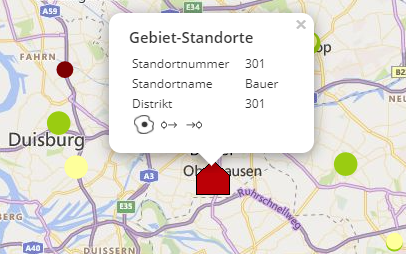
This function allows you to create and calculate a route with stopovers directly in easymap explorer. You may define different start and destination locations by clicking on the circle with the arrow in the data window. All available location-based analyses, territory locations and map layers (e.g. the areas of the 5-digit postal codes) are available as start and destination locations.
Once the start and destination locations of the route have been selected, you can add multiple stopovers to the route. To add a stopover in the route, click on the "pin" in the data window of a location.
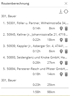
At the top right, the Route Calculation window opens, displaying the travel time in minutes and the travel distance in kilometers. The calculation for the route is optimized by travel time. Here, all common roads or the motorways, the federal roads and the state roads are preferably used for the calculation.
Hint: Traffic information such as traffic jams or road works are not taken into account in the calculation.
Any new stopover you add in the route will be inserted by default at the end of the list in the route window, i.e. the last stops or visits made on the planned route. The order of the route or stops can be rearranged by drag&drop. When you mouse-over a stopover, three dots appear, indicating that you can move this level by holding down the left mouse button.
Here it is also possible to remove the individual stopovers from the route by clicking on the container and to display each individual location on the map by clicking on the "pin". With a click on  the entire route is displayed on the map.
The route can be downloaded and saved as a cvs file. This is very convenient for the field service as they can draw their personal route on the map and download the table with customer information, time and distance for each stopover. In addition, the map can be printed with the designed route. For more information, see the Print chapter.
You can enable and customize this additional feature in the Enable. Here you can make settings or decide which location analyses, territory locations or map layers are taken into account for the route calculation.
Hint: The route calculation only works if the background map BingMaps street maps has been inserted in the workbook.
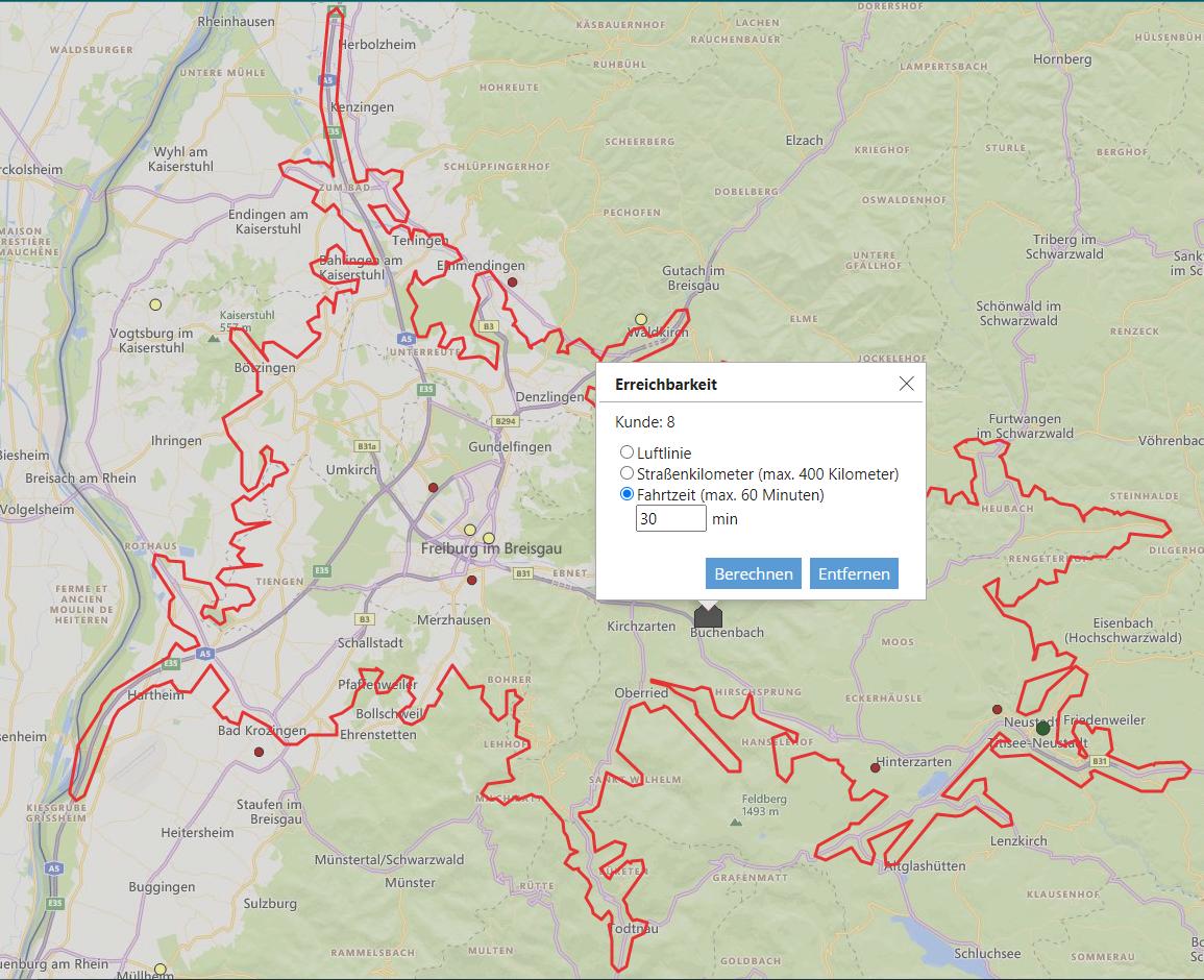
Accessibility
This analysis allows you to display and calculate an isoline around a territory location, symbol or area on the map directly in the browser. With one click on  open the dialog window of the isochrone. Here you can decide whether the calculation should be in kilometers or minutes:
-
Linear distance: A radius of a given distance is drawn around a location.
-
Driving distance: The maximum value of the road kilometer is 400 KM. The calculation for the kilometers refers to the shortest way. Here, all common roads or the motorways, the federal roads and the state roads are preferably used for the calculation.
-
Travel time: The maximum value of the travel time is limited to 60 minutes due to technical reasons of Microsoft. The calculation for the minutes refers to the fastest route. Here, all common roads or the motorways, the federal roads and the state roads are preferably used for the calculation.
Clicking Calculate draws the isoline and clicking inside the isoline reopens the dialog window. The number of elements of all visible location-based analyses (e.g. symbols) in the calculated accessibility analysis, are displayed in the dialog. Multiple isolines can be calculated on the map, but not on the same location. Clicking Remove in the dialog box will remove the isoline.
Hint: Traffic information such as traffic jams or road works are not taken into account in the calculation.
This analysis is useful, for example, in presenting "theoretical" or "ideal" catchment areas of sites and thus contrasting them with actual catchment areas or areas of responsibility.
Accessibility analysis can be enabled at the map level, analogous to route calculation in Share.
Hint: The accessibility analysis only works if the background map BingMaps street maps has been inserted in the workbook.
